Greenways Aiming High
High Line Success Inspires Projects Around the Globe

City of Newark
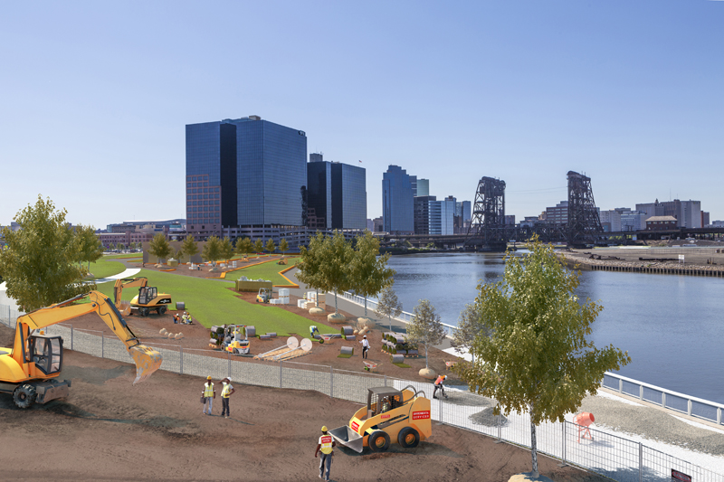
Newark hired the designer behind New York City's High Line to work on the next phase of Riverfront Park.
In St. Louis, a non-profit group is seeking to integrate an abandoned train trestle into its ambitious plans to complete a 600-mile trail network connecting rivers, parks and communities. In Chicago, the city this year celebrated the first birthday of The 606, a recreation trail along an abandoned rail line. In New Jersey, the City of Newark is planning to expand the initial phase of its Riverfront Park built on reclaimed industrial properties along the Passaic River.
And just a few miles away in New York City, there is a campaign to transform a long-abandoned rail line into
The QueensWay, an elevated recreational path connecting six neighborhoods in Queens.
All these projects, in one way or another, are seeking to capture some of the magic of New York City’s High Line, an abandoned rail line that was transformed into a lush oasis 30 feet above the city’s bustling streets.
“It has been an inspiration for scores of cities around the world,” said Adrian Benepe, senior vice president and director of city park development at the Trust for Public Land and former commissioner of the New York City Department of Parks & Recreation.
Since its opening, the High Line has been credited with spurring the revitalization of the Chelsea neighborhood and driving real estate development on properties along its span. It draws New Yorkers and tourists who walk and jog along the reclaimed teak boards, lay in the grass and enjoy the city views.
Across the country communities and advocates are pushing to provide more open space in urban areas, whether it’s transforming old rail lines into trails or finding creative reuses for industrial properties. These public spaces not only make an area more livable, but they have been shown to attract economic development, boost property values and can help improve the health of a community by promoting recreational activities.
But the projects can also be costly, and time consuming—requiring remediation work and significant fundraising before a park can even begin to be built.
Benepe, whose nonprofit has facilitated the creation of parks across the country, said there are ways for every community to offer more public space—they just may need to get creative.
“Things like the High Line, like Brooklyn Bridge Park, like The 606 and Riverfront Park, in every single case what you’re talking about is the adaptive reuse of abandoned or low-functioning infrastructure,” Benepe said. “In every city you’ve got abandoned rail lines, you’ve got former shipping piers and factory sites or elevated highways where there is space underneath.”
As New York City Parks Commissioner, Benepe saw the conversion of school playgrounds into community parks—projects he continues today at the Trust for Public Land. The trust is working with the City of Newark to convert the Lafayette Street Elementary School playground from asphalt into a recreational space that would benefit the city’s Ironbound neighborhood.
The spark that ignites many of these projects is a passionate community coalition or local officials who want to improve a neighborhood—both key components for seeing a project move from a concept to completion.
Great Rivers Greenway
In St. Louis, Missouri, the city’s 1994 centennial celebration prompted civic leaders to question what the area would look like in 100 years. That question led to an open space ballot question and the goal of creating a 600-mile connected greenway in St. Louis County, St. Charles County and St. Louis City—a 1,200-square-mile area that encompasses more than 100 municipalities.
The Great Rivers Greenway regional parks and trail district leads efforts to complete the trail network, which consists of 113 miles so far.
The plan is to connect the area’s rivers, parks and communities.

Nancy Winkelman
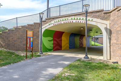
The St. Vincent Greenway is part of Great Rivers Greenway in the
Greater St. Louis area, which aims to create 600 miles of connected trail.
“Being St. Louis we don’t have mountains or beaches,” said Emma Klues, director of communications and outreach for the Great Rivers Greenway. “We have an incredible amount of rivers and creeks, we have an incredible amount of parks and open spaces and other green space to be able to connect to. Our goal is really to create this network among all of those existing assets.”
There are 19 different greenways in the works, which would eventually become interconnected. Some of the trails have been built on highway right-of-way, some are abandoned rail lines. While the greenway has purchased some properties, others have been donated or easements were secured.
The district collects about $21 million annually through the initial proposition and a second ballot question in 2013, which sought funding for the area around St. Louis’ famous Gateway Arch.
Klues said one challenge has been maintaining all of the greenways. While half of the money collected goes back to the counties and city for use on parks, it doesn’t have to be used on the greenway.
Another challenge is prioritizing projects. Great Rivers Greenway is working on a list of top projects, which would not only provide trail links, but also connect multiple communities to help bridge social divides.
Improving Communities
Klues said greenways offer communities a multitude of benefits, something her organization is working to quantify.
“We’ve been trying to measure our impact more and more, so we’ve been working with The Trust for Public Land and other local agencies to see if we can measure property values improving because the greenway went through someone’s neighborhood, or are there ways we can measure health data in areas with more access to places to be outside,” she said.
Benepe, from The Land for Public Trust, said while greenways can have a dramatic impact on a neighborhood it is unlikely projects will compare with the High Line, which led to a dramatic increase in property values.
The High Line has been credited with attracting more than $2 billion in new development. It was also perhaps the most expensive park to build at a total cost of $240 million for 7 acres. The city invested $140 million, the federal government $20 million and the rest came from developer fees and private investment. But Benepe, who was New York City Parks Commissioner when the High Line opened, said the capital outlay was worth the cost for the city.
“That investment has already been amortized in the net new taxes of the 40 new buildings that have gone up around it,” he said. “That’s huge and you wouldn’t see that duplicated in a QueensWay or other places.”
But, he said urban parks and greenways do add value to a community.
“We have done a series of economic value studies of parks systems and basically what we find is that park systems definitely provide value,” Benepe said. “In San Francisco, it’s $1 billion a year in economic value from the parks. Various studies have shown that property adjacent to parks has had a 15 percent increase in value compared to similar property a few blocks away.”
Parks also breathe new life into abandoned properties. Among Benepe’s favorite projects are Olympic Sculpture Park, which revitalized a former oil tank farm in Seattle and Santa Fe Railyard Park, a massive 50 acre site that has more than 13 acres of open space, art galleries, studios and museums.
Creating Parks
Benepe said there is no one-size fits all approach to building a park, but it takes the support of local officials and the community.
One success story is Riverfront Park in Newark, where the trust helped raise public and private funds, engaged the community and oversaw construction of the first phase. Benepe said work on the second phase is set to break ground soon.
The project is complex. Not only does it sit along the Passaic River, a federal superfund site, but the 12-acre park was built on long-neglected, former industrial property. Newark and Essex County worked together to provide the only public greenspace on the city’s waterfront.
The first phase opened in 2012 and features playgrounds, tennis and basketball courts, a turf soccer field and a waterfront walkway and is often bustling with activity. In 2015, voters approved a referendum to increase the city’s open space tax to help fund the park’s expansion.
“I think that level of deep engagement in the local community is what has led to the fact that the park is very popular, it’s very heavily used by the community,” Benepe said.
Newark recently announced the hiring of James Corner Field Operations, the landscape architect behind the High Line, to design an addition to the park.
“This is an incredible opportunity for the City of Newark to transform and re-focus itself around one of its greatest assets—the Passaic River,” said James Corner, CEO of James Corner Fields Operations, in a statement. “With the goal of attracting more people to live in downtown Newark, this one-mile stretch of park can showcase extraordinary and ecologically sound place-making that gives Newark a new image and identity, reflecting the history, culture and resurgence of the City.”
Financing
Just as communities need to be creative when looking for available land to build a park, Benepe said there are different ways to pay for projects.
New York City’s Hudson River Park and Brooklyn Bridge Park, both built on former shipping sites, were designed to be self-sustaining by setting aside some land for future development. The revenue generated from those developments would cover park maintenance costs.
“It’s one of the answers to the questions when people say, we can’t afford to build a park or we can’t afford to maintain it,” he said. “There are interesting mechanisms.”
The High Line generates revenue through rentals and the Friends of the High Line, a non-profit group that maintains the park, also solicits donations.
The Trust for Public Land works with non-profits and communities to raise money to finance projects and maintain them.
The Friends of Bloomingdale Trail approached the trust for help raising money to build the Chicago greenway, known as The 606. Benepe said now that the park is built, the trust may help Chicago with a maintenance plan.
Friends of the QueensWay also approached the trust for help. The Trust for Public Land completed a feasibility study and plan to transform the 3.5-mile abandoned rail line into an elevated pedestrian and bicycle path. The trust is also helping raise money. The project has not yet moved forward, as there is also a proposal to recommission the Long Island Railroad Rockaway Beach Branch, which ceased in 1962.
Even with dedicated funding, financing a project can be difficult. For example, The Trestle, an elevated abandoned rail line over Interstate 70, could become St. Louis’ version of the High Line—but like New York City’s park, it will take years to raise money for the costly venture.
Great Rivers Greenway purchased the 1.5-mile parcel in 2004 for $1.5 million, with plans to connect to the river, but it will cost about $60 million to rehabilitate.
So far the only work that has been done to the remnants of the rail line is painting it green with big white letters that read, “The Trestle, Great Rivers Greenway.”
Klues said the project can’t be completed with the dedicated tax funding alone and it will take a public-private partnership and major investment to make it a reality.
“Because it’s elevated, obviously it’s a little more visible so we have used it as an example because people can relate to the High Line and they can understand what this could do for the region,” she said. “But it’s something that is not going to happen quickly.”
Melissa Hayes is the managing editor of InTransition.